
Oil and gas assets, in the final stage of their operational lifecycle, present a whole host of challenges for oil and gas operators. The decommissioning of mature assets requires a significant amount of resources, involving cost, time and personnel.

Discover B2B Marketing That Performs
Combine business intelligence and editorial excellence to reach engaged professionals across 36 leading media platforms.
Offshore assets, which are typically located in remote locations, can be particularly challenging, as they don’t allow project managers and other related personnel to oversee facilities and their potential environmental impact regularly. Additionally, even after decommissioning, an asset has associated environmental and security risks that make long-term, continual monitoring a necessity for conscientious operators.
Eye in the sky: advanced satellite technologies
A number of satellite providers have in recent years given oil and gas operators access to their range of high-resolution and wide-swath satellite sensors. One such provider, Airbus Defence and Space, not only gives access to its satellites, but also offers value-added services and intelligence solutions, supporting each stage of the oil and gas project lifecycle.
More recently, these satellite-based services have developed into reliable, accurate and user-friendly tools, assisting oil and gas decision makers with valuable and timely intelligence when facing challenges and managing projects.
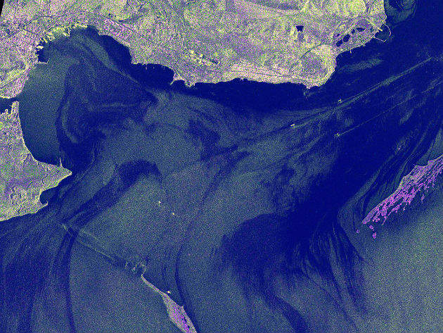
There are two key satellite types with different capabilities: optical sensors, such as the Pléiades satellite constellation, which takes high-resolution images in great detail (50cm resolution); and highly sensitive radar sensors, such as the TerraSAR-X satellite constellation. Radar sensors have the capability of detecting oil leaks offshore, regardless of the weather or light conditions, by identifying the dampening effect an oil slick has on surface waves, providing a highly effective tool to detect environmental issues offshore.

US Tariffs are shifting - will you react or anticipate?
Don’t let policy changes catch you off guard. Stay proactive with real-time data and expert analysis.
By GlobalDataMonitoring ageing assets
Energy infrastructure is built to last for a project’s lifetime. However, as offshore infrastructure operates in extremely challenging environments, assets are exposed to extreme conditions, which cause corrosion and can lead to structural instabilities.
This type of risk can be further exacerbated when operators extend the working-life of assets to exploit their productivity. A recently published Lloyd’s Register white paper stated that up to 70% of the world’s energy production, including nuclear, chemical and petrochemical industries, rely on matured assets.
In addition, the Asset Integrity Services senior vice president Ken Bruce recently highlighted that “the oil and gas industry, as a whole, is trying to delay premature decommissioning in order to maximise the economic recovery of the UKCS (United Kingdom Continental Shelf) as there are still production gains to be realised from many of these assets at the late stage of the lifecycle.”
The extended use of matured assets, coupled with tighter margins and operators’ mixed portfolios of assets which are normally at very different lifecycle stages, illustrate the industry’s need to identify the most cost-effective and flexible inspection methods.
The increased resolution and commercial availability of satellite imaging meets this demand, enabling the cost-effective monitoring of offshore assets on a constant basis. Satellite-based monitoring has the advantage that decision makers can comfortably task image acquisitions directly from their desktop, retrieving information without having to send expensive experts or related team members to the site. This allows managers and engineers to oversee a number of rigs simultaneously, providing valuable information about a rig’s condition, which also enables the efficient planning of more detailed inspections.
The Pléiades satellite constellation’s 50cm resolution offers the ideal imaging technology to monitor assets or assist the planning of inspection activities. Striving to make satellite tasking easier and quicker, Airbus Defence and Space’s new ‘One Tasking’ service has been developed, which allows tasking the high-resolution Pléiades constellation amongst other sensors, within minutes, with an unprecedented guarantee to deliver only the most useful results.
The decommissioning stage
When an offshore site’s production ceases and matured assets enter the decommissioning stage, satellite technologies provide cost-effective support to oversee the decommissioning process and monitor environmental implications.
According to Decom North Sea, a not for profit organisation working to minimise decommissioning costs, there are more than 600 offshore oil and gas operations of varying size and a network of more than 10,000km of pipelines in the North Sea. Many of these structures have been producing oil and gas for over 40 years. The growing numbers of installations which will have to be taken out of service requires effective environmental monitoring technologies and effective project management throughout their decommissioning stages.
The decommissioning process of an offshore facility can take several years, based on numerous factors, including the structure’s age, water depth, platform type, weight, weather and the applicable laws. As each country and region has its own legal and taxation regulations for the decommissioning process, coordinating a global network of resources and sites can be challenging and the right, cost-effective tools can make a difference.
One Tasking’s sub-product, OnePlan can then be scheduled to take up-to-date images of each decommissioning milestone, providing practical detail to decision makers on the project’s progress.
Environmental monitoring
Radar satellite technology is one of the key tools to monitor environmental implications. For example, if a pipeline is damaged during decommissioning activities, radar sensors can pinpoint any resulting oil pollution on the sea surface. The images can then help to understand the leak’s source point, providing crucial information for emergency response planning.
Regardless of the selected decommissioning solution, which could, for example, mean that the structure is left in situ, sunk to the seabed or that only the structure’s upper part is removed, regular monitoring is necessary to ensure the site is safe, complies with all relevant regulations and doesn’t have an environmental impact.


