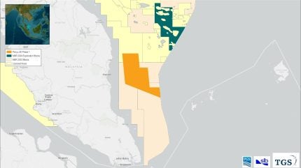
Norwegian seismic companies PGS and TGS, in collaboration with US oilfield services company SLB, have initiated a multi-client 3D seismic project in the Penyu Basin offshore Peninsular Malaysia.
The survey will provide insights into exploration opportunities in the region and assess the potential for carbon storage.
The seismic survey, conducted in partnership with Malaysia Petroleum Management (MPM) on behalf of Petronas, aims to support clients in evaluating exploration prospects and carbon storage capabilities ahead of the upcoming Malaysia Bid Round.
The data acquired from this project will be crucial for companies looking to participate in the competitive bidding process.
TGS CEO Kristian Johansen said: “The Penyu Basin is one of South East Asia’s most exciting yet underexplored frontier exploration hotspots, with the potential of uncovering new exploration plays and CCS [carbon capture and storage] opportunities.
“We are pleased to be able to collaborate with MPM and our JV [joint venture] partners to spearhead exploration in this region through a state-of the-art Geostreamer multi-client 3D acquisition programme.”
How well do you really know your competitors?
Access the most comprehensive Company Profiles on the market, powered by GlobalData. Save hours of research. Gain competitive edge.

Thank you!
Your download email will arrive shortly
Not ready to buy yet? Download a free sample
We are confident about the unique quality of our Company Profiles. However, we want you to make the most beneficial decision for your business, so we offer a free sample that you can download by submitting the below form
By GlobalDataPGS president and CEO Rune Olav Pedersen said: ” This survey marks a change in how clients use newly acquired multi-client seismic data. In addition to the traditional oil and gas exploration activities, this data will be used to facilitate assessment of CCS potential.
“By acquiring multi-client seismic data with our Ramform vessels and GeoStreamer technology, we will provide high-quality regional-scale seismic data that will improve regional understanding of the subsurface.”
The Ramform Sovereign vessel, an advanced seismic ship, was deployed to the designated acquisition area in March 2024.
The survey covers an extensive area of approximately 7,800km².
The acquisition phase is expected to be completed by July 2024, with the data processing projected to conclude by June 2025, the JV partners said.


